


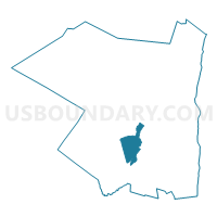
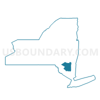
Voting District 140001, Ulster County, New York
About
Outline

Summary
| Unique Area Identifier | 638082 |
| Name | Voting District 140001 |
| County | Ulster County |
| State | New York |
| Area (square miles) | 23.01 |
| Land Area (square miles) | 22.88 |
| Water Area (square miles) | 0.13 |
| % of Land Area | 99.42 |
| % of Water Area | 0.58 |
| Latitude of the Internal Point | 41.75137910 |
| Longtitude of the Internal Point | -74.24647040 |
Maps

Graphs
Select a template below for downloading or customizing gragh for Voting District 140001, Ulster County, New York


Neighbors
Neighoring Voting District (by Name) Neighboring Voting District on the Map
- Voting District 030001, Ulster County, NY
- Voting District 030003, Ulster County, NY
- Voting District 090004, Ulster County, NY
- Voting District 140002, Ulster County, NY
- Voting District 140004, Ulster County, NY
- Voting District 140005, Ulster County, NY
- Voting District 200003-200005 200008 200009 200012, Ulster County, NY
Top 10 Neighboring County Subdivision (by Population) Neighboring County Subdivision on the Map
- Wawarsing town, Ulster County, NY (13,157)
- Rochester town, Ulster County, NY (7,313)
- Gardiner town, Ulster County, NY (5,713)
- Marbletown town, Ulster County, NY (5,607)
Top 10 Neighboring Place (by Population) Neighboring Place on the Map
Top 10 Neighboring Unified School District (by Population) Neighboring Unified School District on the Map
- Wallkill Central School District, NY (20,628)
- New Paltz Central School District, NY (19,569)
- Rondout Valley Central School District, NY (16,868)
- Ellenville Central School District, NY (12,869)
Top 10 Neighboring State Legislative District Lower Chamber (by Population) Neighboring State Legislative District Lower Chamber on the Map
Top 10 Neighboring State Legislative District Upper Chamber (by Population) Neighboring State Legislative District Upper Chamber on the Map
Top 10 Neighboring 111th Congressional District (by Population) Neighboring 111th Congressional District on the Map
Top 10 Neighboring Census Tract (by Population) Neighboring Census Tract on the Map
- Census Tract 9542, Ulster County, NY (5,713)
- Census Tract 9529, Ulster County, NY (5,607)
- Census Tract 9550, Ulster County, NY (5,471)
- Census Tract 9545, Ulster County, NY (4,732)
- Census Tract 9530, Ulster County, NY (1,842)
Top 10 Neighboring 5-Digit ZIP Code Tabulation Area (by Population) Neighboring 5-Digit ZIP Code Tabulation Area on the Map
- 12589, NY (17,228)
- 12446, NY (5,061)
- 12404, NY (3,385)
- 12525, NY (3,311)
- 12484, NY (2,733)
- 12440, NY (1,980)